


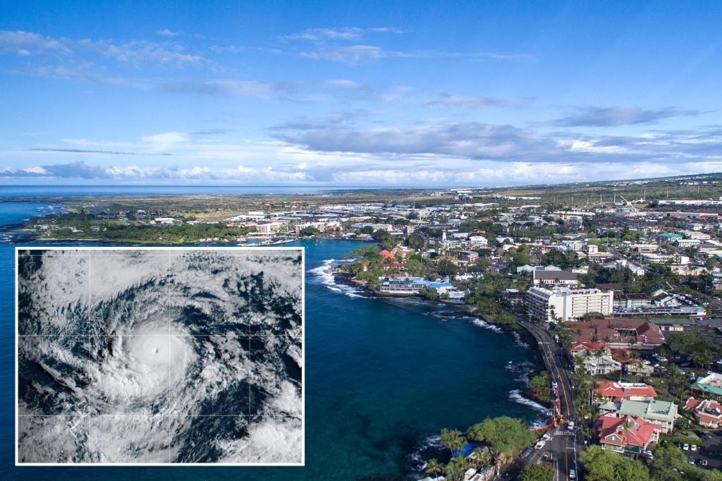
Hurricane Kiko continues to intensify in the eastern Pacific Ocean as it treks toward the west in the general direction of Hawaii, but at this point, it is not expected to bring major impacts to the islands.
As of Wednesday, the National Hurricane Center reported that the nearly Category 3 hurricane was approximately 1,665 miles east of Hilo, but dry air and cooler water temperatures were expected to act as a significant barrier between the cyclone and the islands.
NWS forecasters in Honolulu noted that cyclones often weaken as they approach the islands due to cooler waters and wind shear.
Forecast models suggest that the cyclone will make its closest approach to Hawaii late next week, but the exact impacts, whether it is an increase in shower activity or heightened waves, remain to be determined.
Satellites estimate that sea surface temperatures between the hurricane and the Big Island of Hawaii are in the mid-70s, which is considered to be cooler than what a cyclone typically needs for strengthening.
Hurricane experts widely consider water temperatures of at least 79 degrees to be warm enough for storm systems to organize and strengthen.
Officials in Hawaii are accustomed to closely monitoring tropical systems, but direct landfalls are rare, primarily because of the sea surface temperatures.
Data from NOAA shows only four major hurricanes with winds of at least 115 mph passing within 50 miles of the 137 Hawaiian Islands.
In August 2021, the remnants of Hurricane Linda passed directly over parts of the state after the system weakened into a non-trackable entity.
The remnants produced heavy rainfall on some islands, with elevated waves on north and east-facing beaches.
In 2020, Hurricane Douglas came even closer and triggered the issuance of watches and warnings, but still did not make a direct landfall.
On average, Hawaii experiences outer fringe impacts from a tropical cyclone every year or two, but the amount of activity is usually dependent on the status of the El Niño Southern Oscillation, or what is commonly referred to as the ENSO.
According to NOAA’s hurricane database, the impact rate of hurricanes on the islands is lower during La Niña events and substantially higher during what are considered to be either neutral or El Niño years.
Similar to the Atlantic basin hurricane season, cyclone activity in the central Pacific tends to peak during the August-October timeframe, before coming to an end in November and December.
Read the full article here


